
上河内岳 topographic map
Interactive map
Click on the map to display elevation.
About this map
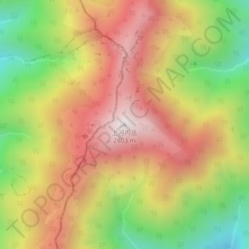
Name: 上河内岳 topographic map, elevation, terrain.
Location: 上河内岳, 静岡市, 静岡県, 420-8602, 日本 (35.38957 138.15276 35.38967 138.15286)
Average elevation: 2,321 m
Minimum elevation: 1,785 m
Maximum elevation: 2,790 m
上河内岳(かみこうちだけ)は、静岡市葵区と長野県飯田市の境界に位置する標高2,803 mの山である。赤石山脈南部の南アルプス国立公園内にあり、日本二百名山に選定されている。
Other topographic maps
Click on a map to view its topography, its elevation and its terrain.