
葵区 topographic map
Interactive map
Click on the map to display elevation.
About this map
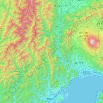
Name: 葵区 topographic map, elevation, terrain.
Location: 葵区, 静岡市, 静岡県, 中部地方, 420-8602, 日本 (34.94956 138.08296 35.64596 138.43697)
Average elevation: 866 m
Minimum elevation: 0 m
Maximum elevation: 3,757 m
区域は、概ね2003年4月1日に旧清水市と合併する前の旧静岡市域の内、東海道本線以北から旧長田村域を除いたものである。政令指定都市の行政区としては日本一の面積である。これは葵区の8割以上、静岡市全体の約60%の面積を占める山間部の旧安倍郡(面積849.36km2)を擁するためであり、市街地として利用しやすい低地や平地はきわめて狭小である。また静岡市内の最高地点(間ノ岳 標高3,189.5m)を有する。
Other topographic maps
Click on a map to view its topography, its elevation and its terrain.