
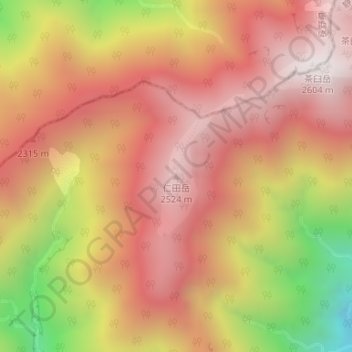
仁田岳 topographic map
Interactive map
Click on the map to display elevation.
About this map
Name: 仁田岳 topographic map, elevation, terrain.
Location: 仁田岳, 静岡市, 静岡県, 420-8602, 日本 (35.36069 138.12705 35.36079 138.12715)
Average elevation: 2,133 m
Minimum elevation: 1,368 m
Maximum elevation: 2,574 m
Other topographic maps
Click on a map to view its topography, its elevation and its terrain.