
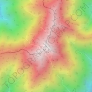
赤石岳 topographic map
Interactive map
Click on the map to display elevation.
About this map
Name: 赤石岳 topographic map, elevation, terrain.
Location: 赤石岳, 静岡市, 静岡県, 420-8602, 日本 (35.46117 138.15730 35.46127 138.15740)
Average elevation: 2,611 m
Minimum elevation: 1,955 m
Maximum elevation: 3,111 m
赤石岳(あかいしだけ)は赤石山脈の長野県と静岡県にまたがる標高3,121 mの山である。南アルプス国立公園内にあり、日本百名山及び新日本百名山に選定されている。
Other topographic maps
Click on a map to view its topography, its elevation and its terrain.