
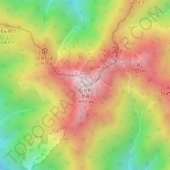
塩見岳 topographic map
Interactive map
Click on the map to display elevation.
About this map
Name: 塩見岳 topographic map, elevation, terrain.
Location: 塩見岳, 静岡市, 静岡県, 420-8602, 日本 (35.57311 138.18358 35.57321 138.18368)
Average elevation: 2,571 m
Minimum elevation: 2,066 m
Maximum elevation: 3,028 m
塩見岳(しおみだけ)は、長野県伊那市と静岡県静岡市葵区にまたがる標高3,052 mの山である。赤石山脈(南アルプス)中央部の南アルプス国立公園内にあり、山頂周辺はその特別保護地区に指定されている。頂上は長野県伊那市の最高点である。
Other topographic maps
Click on a map to view its topography, its elevation and its terrain.