
駿河区 topographic map
Interactive map
Click on the map to display elevation.
About this map
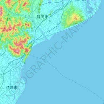
Name: 駿河区 topographic map, elevation, terrain.
Location: 駿河区, 静岡市, 静岡県, 中部地方, 422-8550, 日本 (34.80196 138.29157 35.00623 138.55771)
Average elevation: 33 m
Minimum elevation: -1 m
Maximum elevation: 515 m
Other topographic maps
Click on a map to view its topography, its elevation and its terrain.