
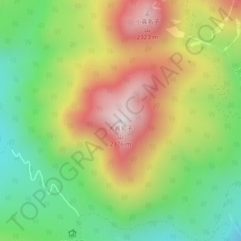
大真名子山 topographic map
Interactive map
Click on the map to display elevation.
About this map
Name: 大真名子山 topographic map, elevation, terrain.
Location: 大真名子山, 日光市, 栃木県, 日本 (36.79524 139.50705 36.79534 139.50715)
Average elevation: 1,928 m
Minimum elevation: 1,592 m
Maximum elevation: 2,342 m
大真名子山(おおまなこさん)は日光国立公園内、栃木県日光市にある山。標高2,376m。三等三角点「大真名子山」(標高2,375.4m)が設置されている。
Other topographic maps
Click on a map to view its topography, its elevation and its terrain.