
鶏頂山 topographic map
Interactive map
Click on the map to display elevation.
About this map
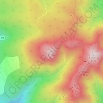
Name: 鶏頂山 topographic map, elevation, terrain.
Location: 鶏頂山, 日光市, 栃木県, 日本 (36.90088 139.76291 36.90098 139.76301)
Average elevation: 1,447 m
Minimum elevation: 1,050 m
Maximum elevation: 1,770 m
鶏頂山(けいちょうざん)は栃木県日光市にある標高1,765mの火山。山体は日光国立公園に属す。日本三百名山のひとつ(それは高原山系のことであり鶏頂山はそのピークのひとつに過ぎない)
Other topographic maps
Click on a map to view its topography, its elevation and its terrain.