
男体山 topographic map
Interactive map
Click on the map to display elevation.
About this map
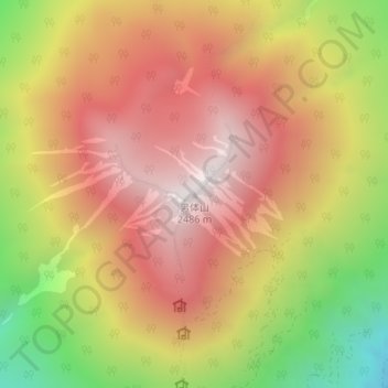
Name: 男体山 topographic map, elevation, terrain.
Location: 男体山, 日光市, 栃木県, 321-1661, 日本 (36.76503 139.49070 36.76513 139.49080)
Average elevation: 1,985 m
Minimum elevation: 1,308 m
Maximum elevation: 2,468 m
男体山(なんたいさん)は栃木県日光市にある標高2,486mの火山。山体は日光国立公園に属す。日本百名山のひとつ。日光二荒山神社の境内地で冬季入山禁止(霊峰男体山の登拝期間は、毎年5月5日から10月25日までであったが、2019年より4月25日から11月11日までに延長された)。
Other topographic maps
Click on a map to view its topography, its elevation and its terrain.