
中禅寺湖 topographic map
Interactive map
Click on the map to display elevation.
About this map
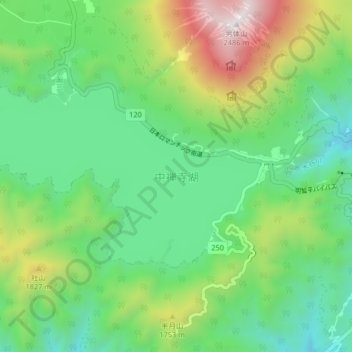
Name: 中禅寺湖 topographic map, elevation, terrain.
Location: 中禅寺湖, 日光市, 栃木県, 日本 (36.72012 139.42030 36.75360 139.49681)
Average elevation: 1,435 m
Minimum elevation: 987 m
Maximum elevation: 2,468 m
中禅寺湖は、約2万年前に男体山の噴火でできた堰止湖である。人造湖を除く広さ4km2以上の湖としては、日本一標高の高い場所にある湖である。また、栃木県最大の湖である。1周は約25kmであり、歩くと9時間ほどかかる距離である。湖のすぐ北には男体山がそびえ、北西には戦場ヶ原が広がる。
Other topographic maps
Click on a map to view its topography, its elevation and its terrain.