
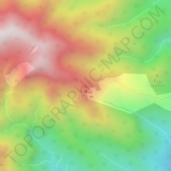
赤薙山 topographic map
Interactive map
Click on the map to display elevation.
About this map
Name: 赤薙山 topographic map, elevation, terrain.
Location: 赤薙山, 日光市, 栃木県, 日本 (36.80915 139.56914 36.80925 139.56924)
Average elevation: 1,686 m
Minimum elevation: 1,167 m
Maximum elevation: 2,226 m
赤薙山(あかなぎさん)は日光国立公園内、栃木県日光市にある山。標高2,010m。三等三角点「赤薙山」(標高2,010.3m)が設置されている。第四紀の成層火山である。
Other topographic maps
Click on a map to view its topography, its elevation and its terrain.