
兵庫区 topographic map
Interactive map
Click on the map to display elevation.
About this map
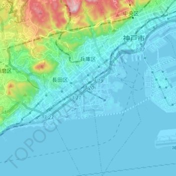
Name: 兵庫区 topographic map, elevation, terrain.
Location: 兵庫区, 神戸市, 兵庫県, 日本 (34.61350 135.13775 34.71454 135.19936)
Average elevation: 60 m
Minimum elevation: -7 m
Maximum elevation: 439 m
Other topographic maps
Click on a map to view its topography, its elevation and its terrain.