
枚方市 topographic map
Interactive map
Click on the map to display elevation.
About this map
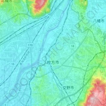
Name: 枚方市 topographic map, elevation, terrain.
Location: 枚方市, 大阪府, 日本 (34.77308 135.61426 34.88134 135.74660)
Average elevation: 42 m
Minimum elevation: -6 m
Maximum elevation: 330 m
市の地形は標高によって大きく4つに区分される。市の東端部は標高100m以上の山地地区となっており、山並が生駒山地に連なっている。山地地区の西側は標高50m〜100mの山麓地区となっており、長尾丘陵が広がる。
Other topographic maps
Click on a map to view its topography, its elevation and its terrain.