
大阪狭山市 topographic map
Interactive map
Click on the map to display elevation.
About this map
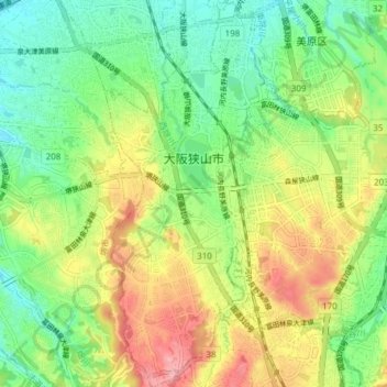
Name: 大阪狭山市 topographic map, elevation, terrain.
Location: 大阪狭山市, 大阪府, 日本 (34.46650 135.53264 34.52942 135.56677)
Average elevation: 92 m
Minimum elevation: 43 m
Maximum elevation: 164 m
狭山の地名は河内国丹比郡(のち分割され丹南郡)の郷名に由来し東の羽曳野丘陵と西の河泉丘陵に挟まれた地形による。
Other topographic maps
Click on a map to view its topography, its elevation and its terrain.