
八尾市 topographic map
Interactive map
Click on the map to display elevation.
About this map
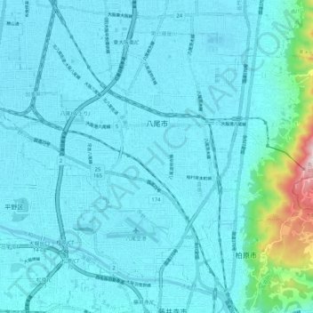
Name: 八尾市 topographic map, elevation, terrain.
Location: 八尾市, 大阪府, 日本 (34.58333 135.56186 34.65078 135.66429)
Average elevation: 43 m
Minimum elevation: 0 m
Maximum elevation: 469 m
大阪平野の中部、大阪市の東南部に隣接し、市域西側は概ね平坦で標高は10メートル程度である。市の東部は高安山をはじめとする急峻な生駒山系が控えており、奈良県との府県境を形成している。市の南端を大和川が流れる他、旧大和川水系である長瀬川、玉串川などの小河川も見られる。
Other topographic maps
Click on a map to view its topography, its elevation and its terrain.