
能勢町 topographic map
Interactive map
Click on the map to display elevation.
About this map
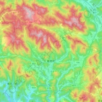
Name: 能勢町 topographic map, elevation, terrain.
Location: 能勢町, 豊能郡, 大阪府, 563-0341, 日本 (34.92628 135.33020 35.05129 135.49360)
Average elevation: 378 m
Minimum elevation: 111 m
Maximum elevation: 776 m
大阪府最北端に位置し、町内は山林・田畑が多く存在する。「大阪の軽井沢」「大阪の北海道」「大阪のチベット」と表現される場合があり、この表現から推察されるように、町内全域が標高200m(天王地区は500m)地帯で大阪市内と6~10℃気温差があり、夏は涼しいものの、冬は氷点下まで冷え込むことが多い。最高気温は、夏の8月が30.9℃ 冬の1月が7.1℃ 最低気温は、夏の8月が21.3℃ 冬の1月が-2.2℃ 特に冬場の冷え込みは、厳しいこともあり、2012年2月3日には、-9.1℃を記録している。(天王付近ではー13℃)年平均気温13.5℃
Other topographic maps
Click on a map to view its topography, its elevation and its terrain.