
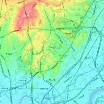
吹田市 topographic map
Interactive map
Click on the map to display elevation.
About this map
Name: 吹田市 topographic map, elevation, terrain.
Location: 吹田市, 大阪府, 日本 (34.74457 135.48680 34.83088 135.55565)
Average elevation: 33 m
Minimum elevation: -1 m
Maximum elevation: 123 m
標高は、1.5mから115.7m。
Other topographic maps
Click on a map to view its topography, its elevation and its terrain.