
大水上山 topographic map
Interactive map
Click on the map to display elevation.
About this map
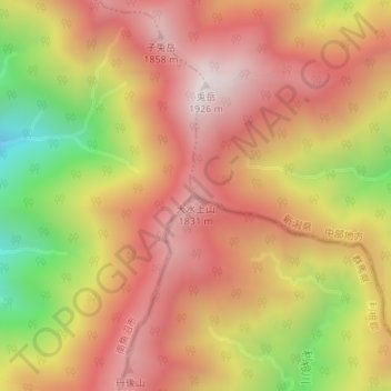
Name: 大水上山 topographic map, elevation, terrain.
Location: 大水上山, みなかみ町, 利根郡, 群馬県, 日本 (37.05850 139.09700 37.05860 139.09710)
Average elevation: 1,537 m
Minimum elevation: 969 m
Maximum elevation: 1,908 m
Other topographic maps
Click on a map to view its topography, its elevation and its terrain.