
白毛門 topographic map
Interactive map
Click on the map to display elevation.
About this map
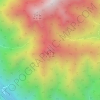
Name: 白毛門 topographic map, elevation, terrain.
Location: 白毛門, みなかみ町, 利根郡, 群馬県, 日本 (36.85950 138.96731 36.85960 138.96741)
Average elevation: 1,362 m
Minimum elevation: 733 m
Maximum elevation: 1,903 m
Other topographic maps
Click on a map to view its topography, its elevation and its terrain.