
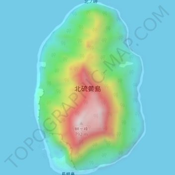
北硫黄島 topographic map
Interactive map
Click on the map to display elevation.
About this map
Name: 北硫黄島 topographic map, elevation, terrain.
Location: 北硫黄島, 小笠原支庁, 東京都, 日本 (25.41878 141.27213 25.44894 141.29353)
Average elevation: 147 m
Minimum elevation: -6 m
Maximum elevation: 781 m
Other topographic maps
Click on a map to view its topography, its elevation and its terrain.