
御蔵島 topographic map
Interactive map
Click on the map to display elevation.
About this map
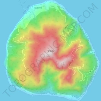
Name: 御蔵島 topographic map, elevation, terrain.
Location: 御蔵島, 東京都, 日本 (33.85168 139.57658 33.90116 139.63207)
Average elevation: 260 m
Minimum elevation: 0 m
Maximum elevation: 831 m
東京都心の南約190キロメートル、三宅島の南南東19キロメートルの太平洋上に位置する。島はほぼ円形をしており、面積20.55平方キロメートル、周囲16.4キロメートルで、中央に標高851メートルの御山(おやま)を擁する。島全体が豊かな原生林で覆われているため、島としては珍しく水に恵まれている。
Other topographic maps
Click on a map to view its topography, its elevation and its terrain.