
箱根山 topographic map
Interactive map
Click on the map to display elevation.
About this map
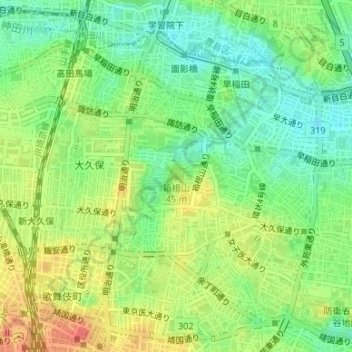
Name: 箱根山 topographic map, elevation, terrain.
Location: 箱根山, 東京都, 162-0052, 日本 (35.70365 139.71346 35.70375 139.71356)
Average elevation: 32 m
Minimum elevation: 7 m
Maximum elevation: 62 m
箱根山(はこねやま)は、東京都新宿区戸山二丁目にある、山手線内にて一番標高が高い人造の山(築山)である。山頂にある水準点の標高は44.6mである。戸山公園内にあり、付近住民や行楽客の憩いの場所である。
Other topographic maps
Click on a map to view its topography, its elevation and its terrain.