
聟島 topographic map
Interactive map
Click on the map to display elevation.
About this map
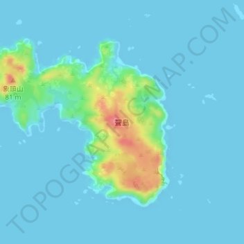
Name: 聟島 topographic map, elevation, terrain.
Location: 聟島, 小笠原支庁, 東京都, 日本 (27.67058 142.12359 27.68926 142.14882)
Average elevation: 10 m
Minimum elevation: 0 m
Maximum elevation: 82 m
島で最も標高が高いのは大山(88m)であり、島の東部に存在する。西部には象頭山と聟島小富士、属島の小島である聟島鳥島が存在する。中部の南側には南浜が存在し、上陸地点になっている。
Other topographic maps
Click on a map to view its topography, its elevation and its terrain.