
残堀川 topographic map
Interactive map
Click on the map to display elevation.
About this map
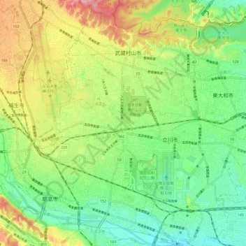
Name: 残堀川 topographic map, elevation, terrain.
Location: 残堀川, 東京都, 208-0034, 日本 (35.68481 139.34858 35.77580 139.40942)
Average elevation: 112 m
Minimum elevation: 64 m
Maximum elevation: 187 m
地形は狭山丘陵と立川崖線を越える部分を除いてほぼ平坦である。
Other topographic maps
Click on a map to view its topography, its elevation and its terrain.