
伊豆大島 topographic map
Interactive map
Click on the map to display elevation.
About this map
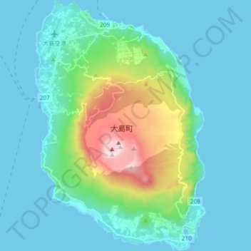
Name: 伊豆大島 topographic map, elevation, terrain.
Location: 伊豆大島, 東京都, 日本 (34.67788 139.34859 34.79910 139.45001)
Average elevation: 125 m
Minimum elevation: -3 m
Maximum elevation: 743 m
伊豆大島は、伊豆・小笠原弧の火山島である。島は水深300〜400kmほどの海底からそびえる火山の陸上部分であり、海底部分まで含めると1,000m程度の高さの火山となる。山頂部にはカルデラがあり、その中には中央火口丘の三原山がある。島の最高地点はこの三原山の標高758mの三原新山と呼ばれる高まりである。
Other topographic maps
Click on a map to view its topography, its elevation and its terrain.