
奈良市 topographic map
Interactive map
Click on the map to display elevation.
About this map
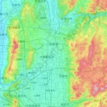
Name: 奈良市 topographic map, elevation, terrain.
Location: 奈良市, 奈良県, 日本 (34.55805 135.71313 34.75774 136.07108)
Average elevation: 195 m
Minimum elevation: 1 m
Maximum elevation: 784 m
現在の奈良市は、奈良県の北部一帯を占める広域市で同時に奈良盆地の北端にも当たる。市東部は大和高原の一部をなし、標高300mから600m級の高地が続く。市街の北は古代に平城山(ならやま)と呼ばれた丘陵地帯で京都府と接している。平城山を越えて山城と通じる奈良坂は古くからの重要交通路の一つ。
Other topographic maps
Click on a map to view its topography, its elevation and its terrain.