
大田区 topographic map
Interactive map
Click on the map to display elevation.
About this map
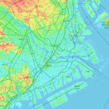
Name: 大田区 topographic map, elevation, terrain.
Location: 大田区, 東京都, 日本 (35.48166 139.65283 35.61309 139.85782)
Average elevation: 10 m
Minimum elevation: -10 m
Maximum elevation: 51 m
池上通りより西側は丘陵部となっており、小規模なアパートや民家、農地が混在している。丘陵部には臼田坂、蓬莱坂など名称を持つ坂が約50ある。標高は東から西に向かって高くなり、最高点では約42.5mとなる。
Other topographic maps
Click on a map to view its topography, its elevation and its terrain.