
嬬恋村 topographic map
Interactive map
Click on the map to display elevation.
About this map
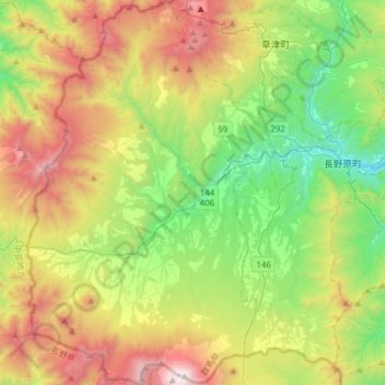
Name: 嬬恋村 topographic map, elevation, terrain.
Location: 嬬恋村, 吾妻郡, 群馬県, 377-1512, 日本 (36.40093 138.39702 36.64828 138.59656)
Average elevation: 1,309 m
Minimum elevation: 544 m
Maximum elevation: 2,560 m
JR吾妻線沿線地域を除く全地域が標高1000m以上の高地に位置するため、亜寒帯湿潤気候である。夏は湿度が低く冷涼で、真夏日日数が多くても4日(2018年)しかないため、避暑地としてにぎわう。一方で、冬は非常に寒さが厳しく北海道並みとなり、多くの年で-15℃前後まで下がる日がある。
Other topographic maps
Click on a map to view its topography, its elevation and its terrain.