
昭島市 topographic map
Interactive map
Click on the map to display elevation.
About this map
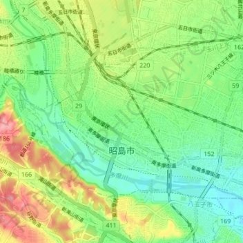
Name: 昭島市 topographic map, elevation, terrain.
Location: 昭島市, 東京都, 日本 (35.69128 139.33153 35.72629 139.39853)
Average elevation: 114 m
Minimum elevation: 73 m
Maximum elevation: 185 m
東京都心より約35キロメートル西の多摩川の左岸に位置しており、市北部には玉川上水が流れている。 また、市の南を流れる多摩川に向かって市域が全体的に北西から南東へ向かって緩やかに傾斜している。市域の標高は、最高地点で海抜170.72 m、最低地点で76.68 mとなっている。(河川部分は除く)
Other topographic maps
Click on a map to view its topography, its elevation and its terrain.