
気仙沼市 topographic map
Interactive map
Click on the map to display elevation.
About this map
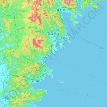
Name: 気仙沼市 topographic map, elevation, terrain.
Location: 気仙沼市, 宮城県, 日本 (38.62027 141.39876 39.00278 142.05136)
Average elevation: 91 m
Minimum elevation: -1 m
Maximum elevation: 872 m
宮城県の北東端に位置し、東は太平洋に面する。東部の唐桑地区から気仙沼地区にかけては、三陸の他地域と同様にリアス式海岸が特徴的である。同じリアス式海岸でも当地方では岩手県沿岸と比較して標高が低く、なだらかな丘陵が多い。唐桑半島と岩井崎の間では、深く入り組んだ海岸線が波の穏やかな気仙沼湾を形成し、湾内には大島が浮かぶ。本吉地区に入ると穏やかな海岸線が見られるようになる。
Other topographic maps
Click on a map to view its topography, its elevation and its terrain.