
富山県 topographic map
Interactive map
Click on the map to display elevation.
About this map
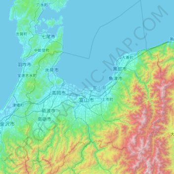
Name: 富山県 topographic map, elevation, terrain.
Location: 富山県, 中部地方, 日本 (36.27437 136.76835 37.25280 137.76338)
Average elevation: 488 m
Minimum elevation: -3 m
Maximum elevation: 3,177 m
富山県は日本海側気候であり、県内全域が豪雪地帯(一部地域は特別豪雪地帯)に指定されている。夏はフェーン現象の影響で気温が上がり、高温多湿。標高の高い南部の山岳地帯は亜寒帯湿潤気候に属し寒さが厳しい。特に立山連峰は世界有数の豪雪地帯であり、立山および剱岳周辺には、氷河が確認されている。 しかし近年では、暖冬傾向にあり、降雪日数は減少してきている。
Other topographic maps
Click on a map to view its topography, its elevation and its terrain.