
淡路島 topographic map
Interactive map
Click on the map to display elevation.
About this map
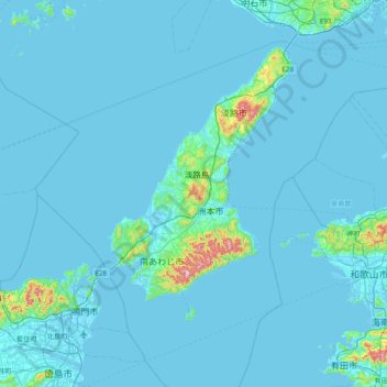
Name: 淡路島 topographic map, elevation, terrain.
Location: 淡路島, 洲本市, 兵庫県, 日本 (34.04538 134.50615 34.68538 135.14615)
Average elevation: 23 m
Minimum elevation: -4 m
Maximum elevation: 582 m
以下の分類は『土地分類図(地形分類図)経済企画庁総合開発局 昭和49年(1974年)発行』による。
Other topographic maps
Click on a map to view its topography, its elevation and its terrain.