
Yamanashi Prefecture topographic map
Interactive map
Click on the map to display elevation.
About this map
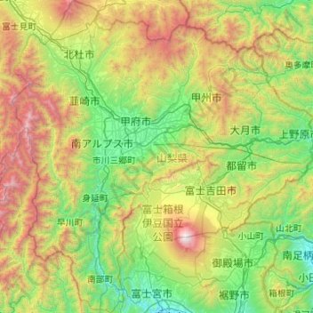
Name: Yamanashi Prefecture topographic map, elevation, terrain.
Location: Yamanashi Prefecture, Chubu Region, Japan (35.16838 138.18009 35.97171 139.13441)
Average elevation: 1,019 m
Minimum elevation: 18 m
Maximum elevation: 3,719 m
78% of the prefecture is covered by forests, making it one of the most densely wooded prefectures in Japan. Land cultivated for agriculture is mainly restricted to the lower elevations of the Kōfu basin.
Other topographic maps
Click on a map to view its topography, its elevation and its terrain.
Motoyama
Motoyama, Nagaoka County, Kochi Prefecture, 781-3601, Japan
Average elevation: 679 m
Niki
Niki, Yoichi County, Shiribeshi Subprefecture, Hokkaido Prefecture, Japan
Average elevation: 269 m
Kusatsu
Kusatsu, Agatsuma County, Gunma Prefecture, Japan
Average elevation: 1,171 m
Kansai Region
Japan > Chubu Region > Nagoya
Kansai Region, Joto, Osaka Prefecture, Japan
Average elevation: 194 m
Nidan Fall
Nidan Fall, Matsumoto, Nagano Prefecture, Japan
Average elevation: 2,048 m
Jodogahama Observation Spot
Jodogahama Observation Spot, 浄土ヶ浜自然歩道, 鍬ヶ崎, Miyako, Iwate Prefecture, 027-0076, Japan
Average elevation: 22 m
Tsuwano
Tsuwano, Kanoashi County, Shimane Prefecture, Japan
Average elevation: 330 m