
種子島 topographic map
Interactive map
Click on the map to display elevation.
About this map
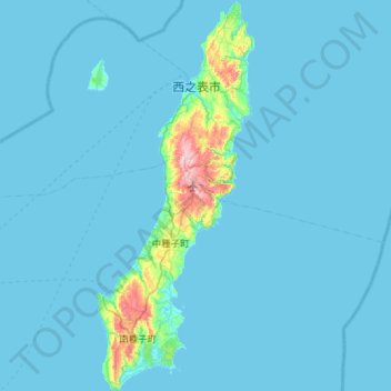
Name: 種子島 topographic map, elevation, terrain.
Location: 種子島, 熊毛郡, 鹿児島県, 日本 (30.34372 130.84872 30.83990 131.08339)
Average elevation: 14 m
Minimum elevation: 0 m
Maximum elevation: 273 m
鹿児島県にある有人離島の中で最も東に位置する。人口(29,282人)は県内では奄美大島に次いで2番目に多く、また、面積(444.30km2)は日本では10番目、県内では奄美大島、屋久島に次いで3番目に大きい。最高地点の標高は回峯(まわりのみね)の282.4 mで、海側から見るとほとんど平らにしか見えず、1,936 mある隣の屋久島と比べると対照的である。中心都市は西之表市。
Other topographic maps
Click on a map to view its topography, its elevation and its terrain.