
Saitama Prefecture topographic map
Interactive map
Click on the map to display elevation.
About this map
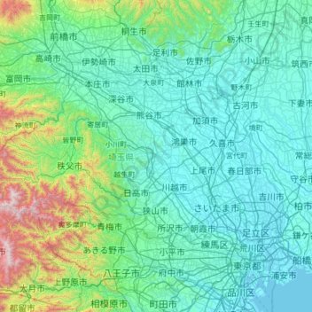
Name: Saitama Prefecture topographic map, elevation, terrain.
Location: Saitama Prefecture, Japan (35.75338 138.71136 36.28341 139.90033)
Average elevation: 230 m
Minimum elevation: -3 m
Maximum elevation: 2,041 m
The topography of Saitama Prefecture is largely divided by the Hachiōji Tectonic Line, which runs through Kodama, Ogawa, and Hannō, into the western mountain area and the eastern lowland area. The altitude, highest on the western side, gradually lowers eastward from mountain ranges to hills to plateaus to lowlands. The eastern lowlands and plateaus occupy 67.3% of the area.
Other topographic maps
Click on a map to view its topography, its elevation and its terrain.
Motoyama
Motoyama, Nagaoka County, Kochi Prefecture, 781-3601, Japan
Average elevation: 679 m
Niki
Niki, Yoichi County, Shiribeshi Subprefecture, Hokkaido Prefecture, Japan
Average elevation: 269 m
Kusatsu
Kusatsu, Agatsuma County, Gunma Prefecture, Japan
Average elevation: 1,171 m
Kansai Region
Japan > Chubu Region > Nagoya
Kansai Region, Joto, Osaka Prefecture, Japan
Average elevation: 194 m
Nidan Fall
Nidan Fall, Matsumoto, Nagano Prefecture, Japan
Average elevation: 2,048 m
Jodogahama Observation Spot
Jodogahama Observation Spot, 浄土ヶ浜自然歩道, 鍬ヶ崎, Miyako, Iwate Prefecture, 027-0076, Japan
Average elevation: 22 m
Tsuwano
Tsuwano, Kanoashi County, Shimane Prefecture, Japan
Average elevation: 330 m