
青梅市 topographic map
Interactive map
Click on the map to display elevation.
About this map
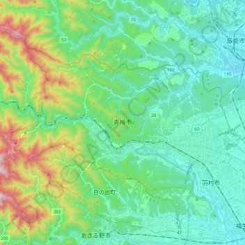
Name: 青梅市 topographic map, elevation, terrain.
Location: 青梅市, 東京都, 日本 (35.75455 139.13716 35.85087 139.33036)
Average elevation: 307 m
Minimum elevation: 80 m
Maximum elevation: 1,041 m
市域のほぼ中央を多摩川が西から東へ貫流し、北部には入間川(荒川水系)の支流である霞川と成木川が、やはり西から東へ流れている。おおむね東部の平地から西部にかけて丘陵地・山地と変化している。標高は西端の多摩川右岸にある御岳の鍋割山の1,084mが最高地点、最低地点は市域の北東に位置する成木川の両郡橋下流で103.5mである。
Other topographic maps
Click on a map to view its topography, its elevation and its terrain.