
福山市 topographic map
Interactive map
Click on the map to display elevation.
About this map
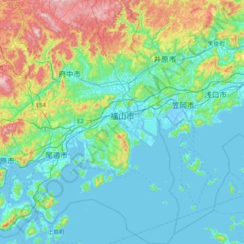
Name: 福山市 topographic map, elevation, terrain.
Location: 福山市, 広島県, 日本 (34.23218 133.21061 34.71213 133.49736)
Average elevation: 133 m
Minimum elevation: -7 m
Maximum elevation: 711 m
三原市北部の大和町を源とする芦田川の河口に広がるデルタ地帯及び江戸時代以降干拓事業により築かれた福山平野に市の中心地がある。市の南端は瀬戸内海に面し、北部山岳地帯は概ね標高400 - 500メートルの吉備高原西南端部にある通称「神石高原」南端から形成される。ここは岡山県倉敷市へ注ぐ高梁川支流小田川流域である。
Other topographic maps
Click on a map to view its topography, its elevation and its terrain.