
盛岡市 topographic map
Interactive map
Click on the map to display elevation.
About this map
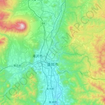
Name: 盛岡市 topographic map, elevation, terrain.
Location: 盛岡市, 岩手県, 日本 (39.56375 140.99525 39.93019 141.52746)
Average elevation: 483 m
Minimum elevation: 92 m
Maximum elevation: 2,022 m
全般に北上盆地の中に位置するため内陸性気候であり、盛岡地方気象台の過去最高気温は37.2℃(1924年7月12日)、過去最低気温は-20.6℃(1945年1月26日)であり、夏と冬、昼と夜とで寒暖差が大きい。市内にある気象庁による観測地点は、中心部にある官署の盛岡地方気象台、市北部の玉山区にあるアメダスの好摩と藪川の計3か所設置されている。ケッペンの気候区分によると、盛岡中心街から南部の北上盆地は温暖湿潤気候、一方市の北部の滝沢市に隣接する地区や北上盆地周辺の標高の高い地域などは亜寒帯湿潤気候に属する。
Other topographic maps
Click on a map to view its topography, its elevation and its terrain.