
鷲羽岳 topographic map
Interactive map
Click on the map to display elevation.
About this map
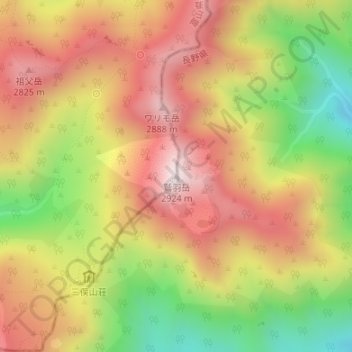
Name: 鷲羽岳 topographic map, elevation, terrain.
Location: 鷲羽岳, 富山市, 富山県, 日本 (36.40297 137.60519 36.40307 137.60529)
Average elevation: 2,557 m
Minimum elevation: 2,126 m
Maximum elevation: 2,912 m
鷲羽岳(わしばだけ)は長野県大町市と富山県富山市にまたがる、北アルプスの標高2,924 mの山である。1934年(昭和9年)12月4日に中部山岳国立公園に指定され、山域はその特別保護地区になっている。また日本百名山にも選定されている。
Other topographic maps
Click on a map to view its topography, its elevation and its terrain.