
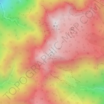
鳶山 topographic map
Interactive map
Click on the map to display elevation.
About this map
Name: 鳶山 topographic map, elevation, terrain.
Location: 鳶山, 富山市, 富山県, 日本 (36.53422 137.58595 36.53432 137.58605)
Average elevation: 2,234 m
Minimum elevation: 1,557 m
Maximum elevation: 2,599 m
標高2,616m。立山連峰の中程に聳え、北に鷲岳、北東に立山、北西に五色ヶ原がある。北北東の獅子岳との鞍部はザラ峠、南の越中沢岳との鞍部は越中沢乗越と呼ばれている。黒部川および常願寺川の源流のひとつであり、山頂付近は森林限界のハイマツ帯である。
Other topographic maps
Click on a map to view its topography, its elevation and its terrain.