
念丈岳 topographic map
Interactive map
Click on the map to display elevation.
About this map
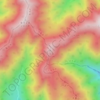
Name: 念丈岳 topographic map, elevation, terrain.
Location: 念丈岳, 飯田市, 長野県, 日本 (35.64761 137.80972 35.64771 137.80982)
Average elevation: 2,020 m
Minimum elevation: 1,579 m
Maximum elevation: 2,292 m
念丈岳(ねんじょうだけ)は、木曽山脈(中央アルプス)にある標高2,291 mの山。
Other topographic maps
Click on a map to view its topography, its elevation and its terrain.