
聖岳 topographic map
Interactive map
Click on the map to display elevation.
About this map
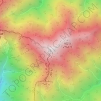
Name: 聖岳 topographic map, elevation, terrain.
Location: 聖岳, 飯田市, 長野県, 日本 (35.42247 138.13959 35.42257 138.13969)
Average elevation: 2,481 m
Minimum elevation: 1,773 m
Maximum elevation: 3,005 m
聖岳(ひじりだけ)は、赤石山脈(南アルプス)南部の静岡市葵区と長野県飯田市の境界に位置する標高3,013 mの山である。日本百名山に選定されている。
Other topographic maps
Click on a map to view its topography, its elevation and its terrain.