Geolocate

Wai topographic map

Click on the map to display elevation.

About this map

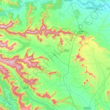
Name: Wai topographic map, elevation, terrain.

Location: Wai, Satara, India (17.80843 73.62813 18.07637 74.05918)

Average elevation: 798 m

Minimum elevation: 550 m

Maximum elevation: 1,424 m

Other topographic maps

Click on a map to view its topography, its elevation and its terrain.

Thiruvananthapuram

India > Kerala > Thiruvananthapuram

Thiruvananthapuram is built on seven hills by the seashore and is at 8°30′N 76°54′E / 8.5°N 76.9°E / 8.5; 76.9 on the west coast, near the southern tip of mainland India. The city is on the west coast of India and is bounded by the Laccadive Sea to its west and the Western Ghats to its east.…

Average elevation: 33 m

Dehradun

India > Uttarakhand > Dehradun

The city of Dehradun mainly lies in Doon Valley and is at a varying height from 410 m (1,350 ft) in Clement Town to above 700 m (2,300 ft) at Malsi which is 15 km (9.3 mi) from the city. However, the average elevation is 450 m (1,480 ft) above sea level. Malsi is the starting point of Lesser Himalayan Range…

Average elevation: 904 m

Ahmedabad

India > Gujarat

Average elevation: 50 m

Mirzapur

India > Uttar Pradesh > Mirzapur

Mirzapur is located at 25°09′N 82°35′E / 25.15°N 82.58°E / 25.15; 82.58. It has an average elevation of 80 metres (265 feet). The District of Mirzapur lies between the parallels of 23.52 & 25.32 North latitude and 82.7 and 83.33 East longitude. It forms a portion of the Varanasi district. On…

Average elevation: 83 m

Jaipur

India > Rajasthan > Jaipur Tehsil

Average elevation: 408 m

Noida

India > Uttar Pradesh > Dadri

Average elevation: 216 m

Vadodara

India > Gujarat > Vadodara Rural Taluka

Vadodara is located at 22°18′N 73°11′E / 22.30°N 73.19°E / 22.30; 73.19 in western India at an elevation of 39 metres (128 ft). It is the tenth-largest city in India with an area of 400 square kilometres (150 sq mi) and a population of 3.5 million, according to the 2010–11 census. The city…

Average elevation: 36 m

Thiruporur

India > Tamil Nadu > Tiruporur

Average elevation: 7 m

Jaisalmer Fort

India > Rajasthan > Jaisalmer Tehsil > Jaisalmer

Average elevation: 238 m

Akluj

India > Maharashtra > Malshiras

Akluj is in Malshiras tehsil and is 120 km (75 mi) away from Solapur city. It is located on the right bank of Nira River. The elevation of Akluj is 551 m (1,808 ft). The latitude 17.9000 and longitude 75.0333. The altitude in feet 1581 Lat (DMS) north 17° 53' 60 N Long (DMS) east 75° 1' 60E altitude (meters)…

Average elevation: 491 m

Surat

India > Gujarat > Katargam Taluka > Surat

Surat is a port city situated on the banks of the Tapi river. Damming of the Tapi caused the original port facilities to close; the nearest port is now in the Magadalla and Hazira area of Surat Metropolitan Region.It has famous beach called 'Dumas Beach' located in Hazira. The city is located at 21°10′N…

Average elevation: 11 m

Bhopal

India > Madhya Pradesh > Huzur Tahsil

Bhopal has an average elevation of 500 metres (1401 ft) and is located in the central part of India, just north of the upper limit of the Vindhya mountain ranges. Located on the Malwa plateau, it is higher than the north Indian plains and the land rises towards the Vindhya Range to the south. The city has…

Average elevation: 498 m

Bhukum

India > Maharashtra > Mulshi

Average elevation: 706 m

Jalpaiguri

India > West Bengal > Jalpaiguri Sadar Block

Average elevation: 84 m

Musi River

India > Telangana > Hyderabad

Average elevation: 490 m

Kangra

India > Himachal Pradesh

Average elevation: 1,665 m

3d

India > Rajasthan > Ganganagar Tehsil > 1 LNP

Average elevation: 178 m

Clement Town

India > Uttarakhand > Dehradun > Dehradun

Clement Town has an average elevation of 410 metres (1,350 ft).

Average elevation: 610 m

Kansai

India > Maharashtra > Shahada Taluka

Average elevation: 211 m

Jaisalmer

India > Rajasthan > Jaisalmer Tehsil

Average elevation: 226 m

Bengre

India > Karnataka > Bhatkal taluk

Average elevation: 9 m

Narepalli

India > Karnataka > Bagepalli taluk

Average elevation: 720 m

Ooty Lake

India > Tamil Nadu > Udhagamandalam > Udhagamandalam

Average elevation: 2,235 m

Navi Mumbai

India > Maharashtra > Thane > Navi Mumbai

Navi Mumbai (Marathi pronunciation: , also known by its former name New Bombay), is a planned city off the west coast of the Indian state of Maharashtra in Konkan division. The city is divided into two parts, North Navi Mumbai and South Navi Mumbai, for the individual development of Panvel Mega City, which…

Average elevation: 30 m

Fort Kagala

India > Karnataka > Kumata taluk > Birkodi

Average elevation: 18 m

Makrana

India > Rajasthan > Makrana Tehsil

Makrana is located at 27°03′N 74°43′E / 27.05°N 74.72°E / 27.05; 74.72, and has an average elevation of 408 metres (1,339 ft). It lies in the middle of the Aravalli Range, and these mountains are the source of its fame as a marble producer.

Average elevation: 427 m

Fort Kagala

India > Karnataka > Kumata taluk > Birkodi

Average elevation: 18 m

Sudsar

India > Rajasthan > Sri Dungargarh Tehsil

Average elevation: 269 m

Avani

India > Karnataka > Mulubagilu taluk

Average elevation: 820 m

Kodiyampalayam

India > Tamil Nadu > Thottiyam

Average elevation: 91 m

Bagiyanda

India > Himachal Pradesh > Bhuntar > Jari

Average elevation: 1,767 m

Gajeha

India > Himachal Pradesh > Karsog

Average elevation: 1,679 m

Pothibasa Chatti

India > Uttarakhand > Ukhimath > Tala

Average elevation: 2,212 m

Siliguri

India > West Bengal > Siliguri Subdivsion

Siliguri located at the foothills of the eastern Himalayas at a location of 26°43′N 88°26′E / 26.71°N 88.43°E / 26.71; 88.43. This city is spread over an area of 260 km2 within the Siliguri Corridor, also known as the Chicken's neck. The city is surrounded by dense forests towards north and…

Average elevation: 121 m

Korramenugunta

India > Andhra Pradesh > Tirupati (Urban)

Average elevation: 142 m

Vishveshvarapura

India > Karnataka > Challakere taluku

Average elevation: 545 m

Aloh

India > Himachal Pradesh > Amb

Average elevation: 677 m

Sector 10

India > Uttar Pradesh > Noida > Dadri

Average elevation: 204 m

Kalruhi

India > Himachal Pradesh > Amb

Average elevation: 510 m

Puluguberpalli

India > Tamil Nadu > Vaniyambadi

Average elevation: 499 m

Tadamanoor

India > Telangana > Andole mandal

Average elevation: 534 m

Naduveerapattu

India > Tamil Nadu

Average elevation: 22 m

Pandli

India > Himachal Pradesh > Kotkhai > Kotkhai

Average elevation: 1,999 m

Chennai

India > Tamil Nadu

Chennai is located on the south–eastern coast of India in the north–eastern part of Tamil Nadu on a flat coastal plain known as the Eastern Coastal Plains. Its average elevation is around 6.7 metres (22 ft), and its highest point is 60 m (200 ft). Chennai is 2,184 kilometres (1,357 mi) south of Delhi,…

Average elevation: 7 m

Daulat Beg Oldi

India

Daulat Beg Oldi (DBO) lies at the northeastern corner of the Karakoram Range, at the northern edge of Depsang Plains at an elevation of 5,100 metres (16,700 ft). The international border with China is 8 km to the north and the Line of Actual Control with Chinese-controlled Aksai Chin is 9 km to the east. Other…

Average elevation: 5,085 m

The Nilgiris

India > Tamil Nadu

Average elevation: 639 m

Mysuru

India > Karnataka > Mysuru taluk

Mysore (/maɪˈsɔːr/ (listen)), officially Mysuru ([ˈmaɪˈsuːɾu] (listen)), is a city in the southern part of the state of Karnataka, India. Mysore city is geographically located between 12° 18′ 26″ north latitude and 76° 38′ 59″ east longitude. It is located at an altitude of 770 m (2,530 ft)…

Average elevation: 727 m

Lucknow

India > Uttar Pradesh > Lucknow

Lucknow stands at an elevation of approximately 123 metres (404 ft) above sea level. The city had an area of 402 km2 (155 square miles) until December 2019, when 88 villages were added to the municipal limits and the area increased to 631 km2 (244 square miles). Bounded on the east by Barabanki, on the west by…

Average elevation: 120 m

Kainakary

India > Kerala > Kuttanad

Average elevation: 2 m

Laxmipur

India > Odisha > Chhatrapur

Average elevation: 27 m

Laxmipur

India > Uttar Pradesh > Moradabad

Average elevation: 192 m

Kavoor

India > Karnataka > Mangaluru taluk

Average elevation: 31 m

Sentosa Water Park

India > Maharashtra > Haveli > Ravet

Average elevation: 577 m

Haragadde

India > Karnataka > Anekal

Average elevation: 903 m

Vachhu

India > Gujarat > Okhamandal Taluka

Average elevation: 19 m

Shantipur

India > West Bengal > Santipur

Santipur is located at 23°15′N 88°26′E / 23.25°N 88.43°E / 23.25; 88.43. It has an average elevation of 15 metres (49 feet).

Average elevation: 11 m

Ubhrat Beach

India > Gujarat > Jalalpore Taluka > Umbhrat

Average elevation: 2 m

Mahipalgad

India > Maharashtra > Chandgad

Average elevation: 848 m

Melukote

India > Karnataka > Pandavapura taluk

Average elevation: 920 m

Kalpetta

India > Kerala > Vythiri

Kalpetta is a city and town and Wayanad Grade 2 municipality in the Wayanad district of the Indian state of Kerala. Kalpetta is the headquarters of the Wayanad district, as well as the headquarters of Vythiri taluk. It is surrounded by dense coffee and tea plantations and mountains. It lies on the…

Average elevation: 809 m

Guntakal

India > Andhra Pradesh > Guntakal

Guntakal is located at 15°10′N 77°23′E / 15.17°N 77.38°E / 15.17; 77.38. It has an average elevation of 432 metres (1,417 ft).

Average elevation: 445 m

Sankot

India > Uttarakhand > Tharali

Average elevation: 2,036 m

Pattithanam

India > Kerala > Meenachil

Pattithanam is a village near Ettumanoor in the Kottayam District of Kerala, India. The name 'Pattithanam' is believed to be given by the Portuguese traders, who were looking for an ideal spot to build a church (St.Boniface Church). Pattithanam(Pattia Sthanam) means ideal place in Malayalam. Pattithanam…

Average elevation: 38 m

Munsyari

India > Uttarakhand > Munsiari tehsil

Average elevation: 2,306 m

Bandipora

India > Jammu and Kashmir > Bandipora

Average elevation: 1,743 m

Majitha

India > Punjab > Majitha Tahsil

Average elevation: 236 m

Shimla

India > Himachal Pradesh

Shimla is on the south-western ranges of the Himalayas at 31°37′N 77°06′E / 31.61°N 77.10°E / 31.61; 77.10. It has an average altitude of 2,206 metres (7,238 ft) above mean sea level and extends along a ridge with seven spurs. The city stretches nearly 9.2 kilometres (5+3⁄4 mi) from east to…

Average elevation: 1,557 m

Bisonia

India > Madhya Pradesh > Shamshabad Tahsil

Average elevation: 484 m

Vadgaon Phata

India > Maharashtra > Alibag Taluka > Karle

Average elevation: 27 m

Bhadesar

India > Madhya Pradesh > Nowgong Tahsil

Average elevation: 256 m

Wyndhamganj

India > Uttar Pradesh > Dudhi

Average elevation: 250 m

Vettinad

India > Kerala > Nedumangad

Average elevation: 61 m

Nawatala Jaitmalan

India > Rajasthan > Chohtan Tehsil

Average elevation: 175 m

3d

India > Rajasthan > Ganganagar Tehsil > 1 LNP

Average elevation: 178 m

Pitrodi

India > Karnataka > Udupi taluku

Average elevation: 6 m

Panvel

India > Maharashtra > Panvel > Panvel

Matheran is a hill station and a municipal council in the Raigad district in the Indian state of Maharashtra. It is a hill station in Karjat Tahsil and is also the smallest hill station in India. It is located on the Western Ghats range at an elevation of around 800 m (2,625 feet) above sea level. It is…

Average elevation: 75 m

Aravalli Range

India > Rajasthan > Abu Road Tehsil

Average elevation: 1,339 m

Madurai

India > Tamil Nadu > Madurai

Madurai is located at 9°56′N 78°07′E / 9.93°N 78.12°E / 9.93; 78.12. It has an average elevation of 101 metres. The city of Madurai lies on the flat and fertile plain of the river Vaigai, which runs in the northwest-southeast direction through the city, dividing it into two almost equal…

Average elevation: 138 m

Giingee

India > Tamil Nadu > Gingee

Gingee is located at 12°15′N 79°25′E / 12.25°N 79.42°E / 12.25; 79.42. It has an average elevation of 92 metres (301 ft).

Average elevation: 102 m

Cola Beach

India > Goa > Canacona

Average elevation: 24 m

Indore

India > Madhya Pradesh > Juni Indore Tahsil

Average elevation: 555 m

Sembanarkoil

India > Tamil Nadu > Tharangambadi

Average elevation: 8 m

Kila Raipur

India > Punjab > Ludhiana (East) Tahsil

Average elevation: 251 m

Kupta

India > Maharashtra > Manora

Average elevation: 447 m

Machapur

India > Telangana

Average elevation: 466 m

Singhawali

India > Uttar Pradesh > Garhmukteshwar

Average elevation: 215 m

Kelansar

India > Rajasthan > Bap Tehsil

Average elevation: 280 m

Nalgaon

India > Uttarakhand > Tharali

Average elevation: 1,297 m

Jamnagar

India > Gujarat > Jamnagar City Taluka

Average elevation: 19 m

Khanola

India > Himachal Pradesh > Rohru > Bhot

Average elevation: 2,147 m

Kulgaon

India > Chhattisgarh > Jagdalpur Tahsil

Average elevation: 565 m

Kolleru

India > Andhra Pradesh > Mandavalli

Average elevation: 4 m

Thippirajapuram

India > Tamil Nadu > Kumbakonam

Average elevation: 25 m

Paranam

India > Tamil Nadu > Sendurai

Average elevation: 97 m

Gundlapalli

India > Karnataka > Bagepalli taluk

Average elevation: 735 m

Nekarikallu

India > Andhra Pradesh > Nekarikallu

Average elevation: 131 m

Asrasar

India > Rajasthan > Lunkaransar Tehsil

Average elevation: 206 m

Kharsia

India > Chhattisgarh > Kharsia Tahsil

Kharsia is located at 21°58′N 83°07′E / 21.97°N 83.12°E / 21.97; 83.12. It has an average elevation of 245 m (804 ft).

Average elevation: 253 m

Gadani

India > Gujarat > Nakhatrana Taluka

Average elevation: 79 m