
Navi Mumbai topographic map
Interactive map
Click on the map to display elevation.
Navi Mumbai
Navi Mumbai (Marathi pronunciation: , also known by its former name New Bombay), is a planned city off the west coast of the Indian state of Maharashtra in Konkan division. The city is divided into two parts, North Navi Mumbai and South Navi Mumbai, for the individual development of Panvel Mega City, which includes the area from Kharghar to Uran. Navi Mumbai has a population of 1,119,477 as per the 2011 provisional census. It has average city elevation excluding forest area of 14 meters.
About this map
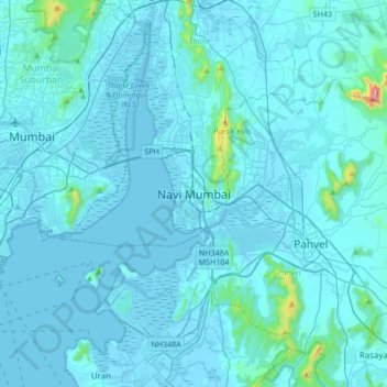
Name: Navi Mumbai topographic map, elevation, terrain.
Average elevation: 30 m
Minimum elevation: -4 m
Maximum elevation: 725 m
Other topographic maps
Click on a map to view its topography, its elevation and its terrain.