
円山 topographic map
Interactive map
Click on the map to display elevation.
About this map
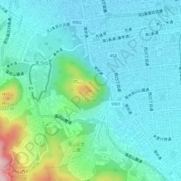
Name: 円山 topographic map, elevation, terrain.
Location: 円山, 札幌市, 石狩振興局, 北海道, 064-0946, 日本 (43.04723 141.31650 43.04733 141.31660)
Average elevation: 70 m
Minimum elevation: 16 m
Maximum elevation: 300 m
円山(まるやま)は、北海道札幌市中央区にある標高225 mの山である。所在地となる地名も同名である。石狩平野に面し、札幌市の中心から西の近くにあり、札幌市民の行楽の場になっている。山の大部分は円山原始林として保護されているが、過去に人の手が入っているので厳密な意味での原始林ではなく、天然林にあたる。
Other topographic maps
Click on a map to view its topography, its elevation and its terrain.