
吉野 topographic map
Interactive map
Click on the map to display elevation.
About this map
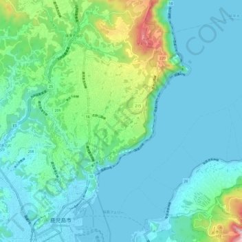
Name: 吉野 topographic map, elevation, terrain.
Location: 吉野, 鹿児島市, 鹿児島県, 892-8677, 日本 (31.59481 130.55339 31.67940 130.66953)
Average elevation: 112 m
Minimum elevation: -1 m
Maximum elevation: 634 m
主要な山としては、牟礼ヶ岡(標高:552m)、寺山(標高:423m)、磯山(標高:169m)があり、谷は関屋谷がある。川は稲荷川、磯川、花倉川が流れる。
Other topographic maps
Click on a map to view its topography, its elevation and its terrain.