
西陵 topographic map
Interactive map
Click on the map to display elevation.
About this map
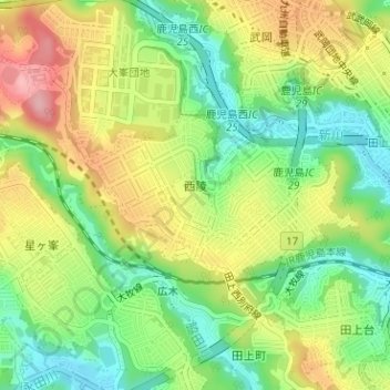
Name: 西陵 topographic map, elevation, terrain.
Location: 西陵, 鹿児島市, 鹿児島県, 892-8677, 日本 (31.57644 130.49799 31.58788 130.52009)
Average elevation: 80 m
Minimum elevation: 13 m
Maximum elevation: 165 m
鹿児島市の西部、新川の中流域の丘陵地上に位置している。町域全体が西別府町と田上町に跨る台地を「西郷団地」として造成した新興住宅地である。最も低い位置にある西陵三丁目(標高30m)から最も高い位置にある西陵八丁目(125m)までの斜面上に住宅が多く所在している。
Other topographic maps
Click on a map to view its topography, its elevation and its terrain.