
Make a donation
Eastern Development Region topographic map
Click on the map to display elevation.
Make a donation
About this map
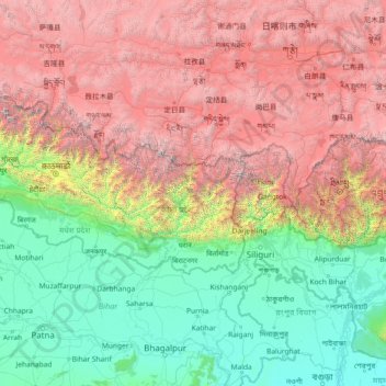
Name: Eastern Development Region topographic map, elevation, terrain.
Location: Eastern Development Region, Koshi Province, Nepal (24.81597 84.80629 30.01597 90.00629)
Average elevation: 2,441 m
Minimum elevation: 9 m
Maximum elevation: 8,419 m
Make a donation
Other topographic maps
Click on a map to view its topography, its elevation and its terrain.
Make a donation
Make a donation
Lomanthang
Nepal > Gandaki Province > Mustang
Lo is the northern two-thirds of Mustang district, culturally and linguistically influenced by Tibet, while the southern third is called Thak, the homeland of Thakali people who speak a different language and have a synthesis of Tibetan and Nepalese culture. In 2007, a series of at least twelve caves were…
Average elevation: 4,949 m
Make a donation
Bagamati Province
Bagmati Province has an area of 20,300 km2 which is about 13.79% of the total area of Nepal. The elevation of the province ranges from 141 m at Golaghat in Chitwan District to 7,422m at Ganesh Himal. The province has an altitude low enough to support deciduous, coniferous, and alpine forests and woodlands.…
Average elevation: 2,234 m
Make a donation
Jumla
Geographically, Jumla is a Himalayan mountainous region of which elevations ranges from 915 metres (3,002 ft) to 4,679 metres (15,351 ft). The Higher Himalayan Region consists of Patarasi and Kanjirowa Himalayan ranges. The major rivers in Jumla are Hima, Tila and Jawa.
Average elevation: 3,373 m
Morang
Morang District (Nepali: मोरङ जिल्ला listen) is located in Koshi Province in eastern Nepal. It is an Outer Terai district. It borders Jhapa to the east, Dhankuta and Panchthar to the north, Sunsari to the west, and Bihar, India, to the south. Morang has one metropolitan city (Biratnagar),…
Average elevation: 262 m
Make a donation
Make a donation
Achham
Nepal > Sudurpashchim Province
Achham covers an area of 1,692 square kilometres (653 sq mi) and located at Latitude: 280°46’ North to 290°23' North and Longitude: 810°32 East to 810°35' East. 90% area of Achham is mid-hill and 10% is high-hill. The maximum elevation of the district is 3,820 metres (12,530 ft) and minimum elevation is…
Average elevation: 1,387 m
Make a donation
Patan
Lalitpur Metropolitan City (Sanskrit: पाटन Pāṭana, Nepal bhasa : 𑐫𑐮 Yela, ) is a Metropolitan city and fourth most populous city of Nepal with 299,843 inhabitants living in 49,044 households per 2021 cencus. It is located in the south-central part of Kathmandu Valley, a large valley in the…
Average elevation: 1,312 m
Make a donation
Dolpa
Dolpa is the largest district of Nepal covering 5.36% of the total landmass of the country. It is located at 28°43’N to 29°43’N latitude and 82°23’E to 83°41’E longitude. Elevation ranges from 1,525 to 7,625 m (5,003 to 25,016 ft). The district borders Tibet on the north and northeast, Jumla and…
Average elevation: 4,555 m
Make a donation
Dhankuta
Dhankuta is a mid-hill district of eastern hill region of Nepal. It is situated between 26°53' to 27°19' north latitude and 87°8' to 88°33' east longitude. Total area of the district is 888.7 square kilometres (343.1 sq mi) and it is located at 243 metres (9,600 in) to 629 metres (24,800 in) of elevation…
Average elevation: 1,098 m
Make a donation
Jhapa
Jhapa receives 250 to 300 cm of rainfall a year, and mostly during the monsoon season in the summer, and its hilly northern area receives more rainfall than the south. The maximum temperature is recorded 42 °C in summer and 10 °C in winter. The lowest elevation point is 58 meter which is the lowest land of…
Average elevation: 171 m
Lumbini Province
The elevations of Dang and Deukhuri valleys are 700 meters and 300 meters from sea level respectively. Late Cenozoic sedimentary sequences are well exposed along the southern part of Dang and all sides of Deukhuri valley, and mostly consist of deformed rocks resulting from the persistence of shortening between…
Average elevation: 1,417 m
Make a donation
Make a donation
Sudurpashchim Pradesh
Surma Sarovar is one of the hidden gems in the Sudurpaschim region. Located at an altitude of 4,300 metres, the trail to get there is not easy. walk past high ridges that get to by crossing passes and also get to walk past small lakes and ponds along with meadows with mountains like Jethi Bahurani. The lake is…
Average elevation: 1,858 m
Make a donation
Make a donation
Make a donation
Modi Rural Municipality Ward No.6
Nepal > Parbat > Modi Rural Municipality Ward No.6
Average elevation: 1,244 m
Make a donation
Make a donation
Make a donation
Make a donation
Province #1
Province No. 1 covers an area of 25,905 km2. The province has three-fold geographical division: Himalayan in the north, Hilly in the middle and Terai in the southern part of Nepal, varying between an altitude of 70 m and 8,848 m. Terai, extended from east to west, is made up of alluvial soil. To the west of…
Average elevation: 2,134 m