
Make a donation
Marpha topographic map
Click on the map to display elevation.
Make a donation
About this map
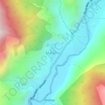
Name: Marpha topographic map, elevation, terrain.
Average elevation: 2,962 m
Minimum elevation: 2,640 m
Maximum elevation: 3,697 m
Make a donation
Other topographic maps
Click on a map to view its topography, its elevation and its terrain.
Lomanthang
Nepal > Gandaki Province > Mustang
Lo is the northern two-thirds of Mustang district, culturally and linguistically influenced by Tibet, while the southern third is called Thak, the homeland of Thakali people who speak a different language and have a synthesis of Tibetan and Nepalese culture. In 2007, a series of at least twelve caves were…
Average elevation: 4,949 m
Jomsom
Nepal > Gandaki Province > Mustang
Jomsom (Nepali: जोमसोम), (Ward No. 4 of Gharpajhong Rural Municipality) also known as Dzongsam (New Fort), is the centre of Gharapjhong rural municipality in Mustang district and a former independent village development committee situated at an altitude of about 2,700 metres (8,900 ft) in Gandaki…
Average elevation: 3,061 m