
Thank you for supporting this site ❤️
Make a donation
Make a donation
Jumla topographic map
Click on the map to display elevation.
Thank you for supporting this site ❤️
Make a donation
Make a donation
Jumla
Geographically, Jumla is a Himalayan mountainous region of which elevations ranges from 915 metres (3,002 ft) to 4,679 metres (15,351 ft). The Higher Himalayan Region consists of Patarasi and Kanjirowa Himalayan ranges. The major rivers in Jumla are Hima, Tila and Jawa.
Thank you for supporting this site ❤️
Make a donation
Make a donation
About this map
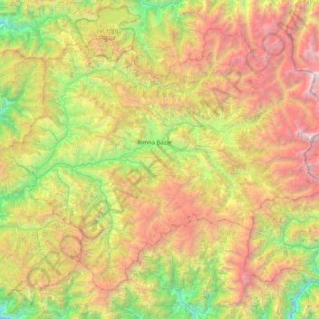
Name: Jumla topographic map, elevation, terrain.
Location: Jumla, Karnali Province, Nepal (28.97129 81.84518 29.50582 82.59085)
Average elevation: 3,373 m
Minimum elevation: 1,352 m
Maximum elevation: 6,533 m
Thank you for supporting this site ❤️
Make a donation
Make a donation
Other topographic maps
Click on a map to view its topography, its elevation and its terrain.